


Committed to Sustainable Cities and Human Settlements for All

In Special Consultative Status with ECOSOC
Abstract: The world’s cities are trying to overcome automobile dependence because of multiple problems from congestion, air pollution and urban sprawl. The alternative of transit with TOD’s (transit oriented development) has been an agenda for 30 years and many new metro projects in cities have used TOD’s to help reduce car dependence. Shanghai and Beijing have shown how this can be done well with clear evidence of peak car in these cities. Now we are suggesting a new phase of urban development called TAC’s (transit activated corridors) that uses mid-tier transit (especially Trackless Trams) to unlock urban development along main roads so that whole corridors of reduced car dependence can be created. Walkable station precincts can result with all the value uplift of new planning initiatives that create liveability and sustainability as part of TAC’s. This can be zero carbon for transport and buildings.
Keywords: PEAK CAR, second rail revolution, Transit Activated Corridors, trackless trams, Mid-Tier Transit, walkable station precincts.
I'm very happy to be part of the International Green
Model City (IGMC) Initiative, and I particularly like the tree of life with all
the good things hanging off it in your symbol. I would like to give you a new
concept for how to create this kind of green model city. I’ve called it from
TOD to TAC - transit oriented development to transit activated corridors.

The Peak Car Era
We are in a new era in cities which others have called Peak Car. It is really a different era because we built our cities around cars in recent decades and it’s not working. This is due to space and time constraints, plus a lot of other things like air quality, climate change and all the SDGs that seem to hang off it. I've been writing about this and collecting data on cities for a long time. Firstly in 1989 “Cities and Automobile Dependence”, then “Sustainability and Cities: how to overcome automobile dependence” and finally “The End of Automobile Dependence: How Cities are Moving Beyond Car-Based Planning.”This has been my life for thirty to forty years.
Urban transport is fundamentally about two issues:
space and time. The space issue is first of all very obvious; just see the
picture (Figure 1) in which those cars can be replaced by three buses, or one
light rail.
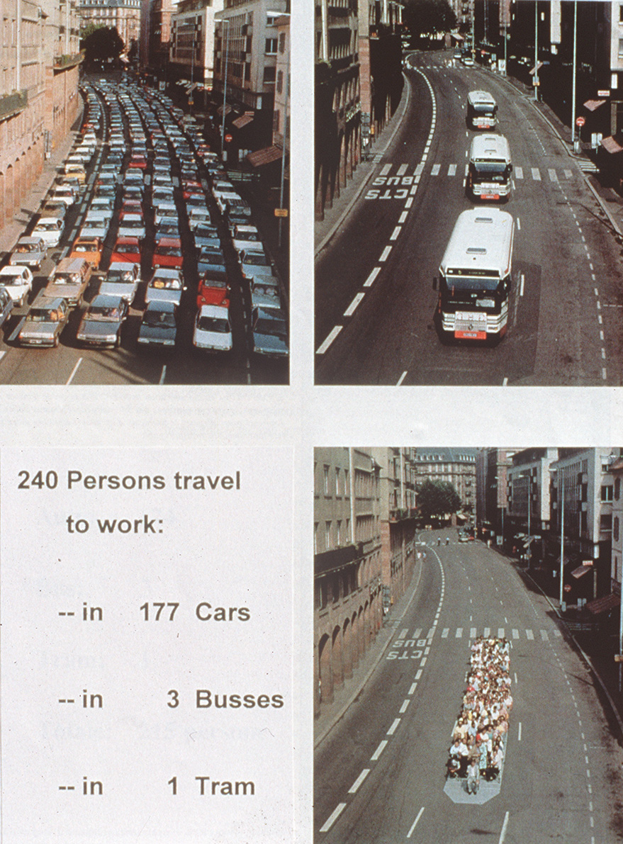
Figure 1: SPACE - capacity of different modes
Massive increases in the space available from
switching modes means more space for doing urban activity, particularly
walkable urban activity, and this is driving the changes we're now looking at.
Cities are choosing walkable spaces over car-saturated spaces.
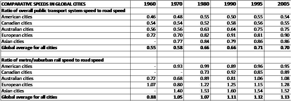
Figure 2: TIME - Rail outstripping traffic speeds
In terms of time, just look for the “1” (Figure 2). If you are one, it means you've got public transport faster than traffic. And none of the cities where you've got buses and trains together are over one as buses get stuck in traffic. But when you just look at rail, most of the Asian cities, European cities, and Australian cities are now over “1”. In other words, you can get around faster by rail than on the road. The Canadian and American cities are getting close to it, but are not quite there.
Second Rail Revolution
These data provide the basis for what we've seen in
the last few decades in the global growth in urban rail. For instance, 82
Chinese cities have or are building metros and high-speed rail covers 20,000
kms of the country; 16 Indian cities have or are building metros and probably
more now; MiddleEast cities are building rail for the first time. It's been a
revival of rail. In the old rail cities, like in the UK, you can see dramatic
increases in rail patronage in the 19th century but in the last few
decades patronage has grown faster than even in the glorious era of rail
(Figure 3). We have called it the second rail revolution.
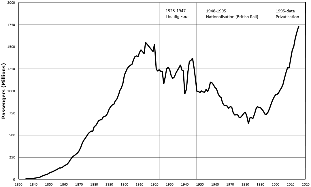
Figure
3: Rail patronage in the UK
Emerging Cities
What about the emerging cities, like Beijing and
Shanghai? We've been studying them recently and if you look at the transition
that Shanghai's been through from the 1990s, there have been dramatic changes
as the city grew economically. They began flirting with the American model of
building freeways, but it didn't work as the roads rapidly filled. Essentially,
what do you do next when the major roads are completely filled? You build a
metro, Shanghai did this in a decade: 12 lines, 273 stations, 420 km railway,
covering 80% of the metro area. It now carries eight million passengers a day,
and it's one of the biggest in the world. The top one is Beijing with 9 million
a day. Shanghai hit peak car in 2009. And the car use began going down from
that period (Figure 4).
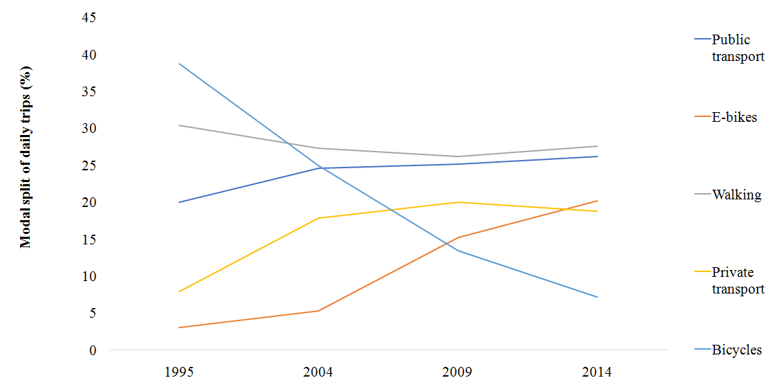
Figure 4: Shanghai hits peak car in 2009
There was a dramatic drop in bicycle use before that
as the car use went up, but then it went down as public transport went up,
mostly in the metro rail. The rail transport is showing a dramatic increase
(Figure 5).
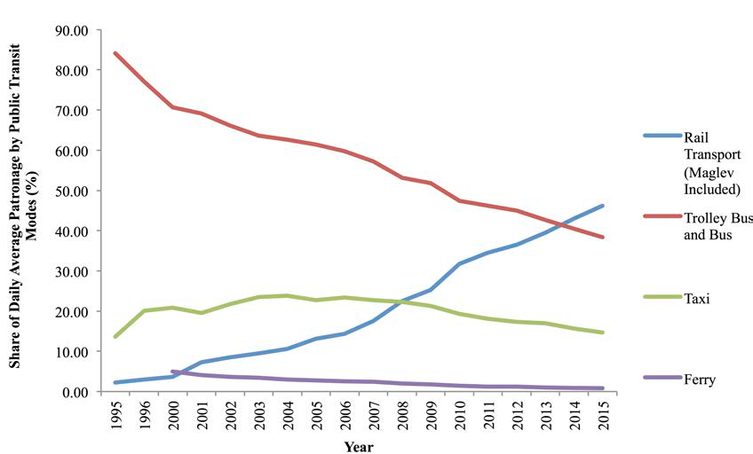
Figure
5: Dramatic growth of rail in Shanghai
The same thing has happened in Beijing where we see transit
going up, bikes coming down and then being replaced by cars and then cars
hitting the wall (Figure 6).Nine million passengers a day are now on the rail
system.
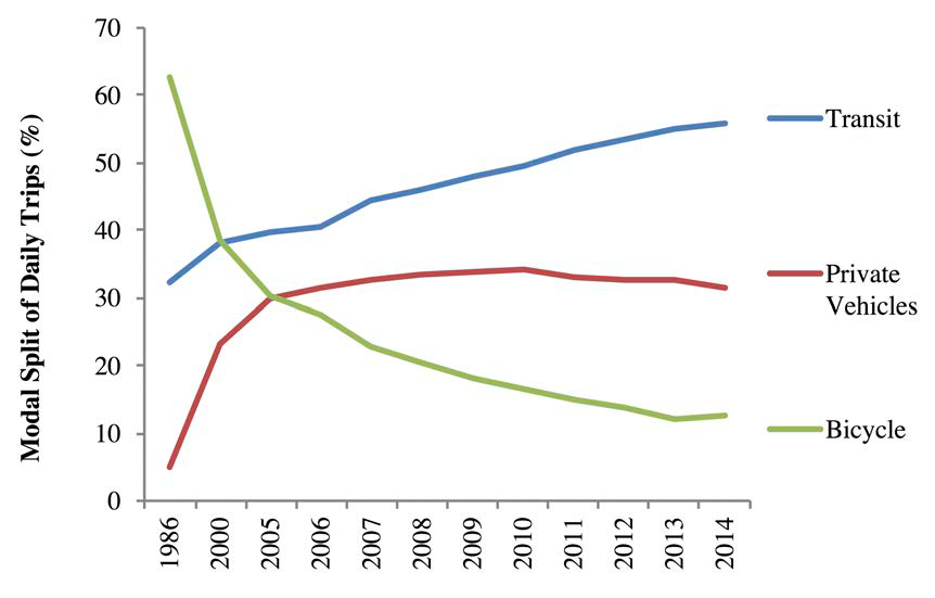
Figure 6: Peak car use and transit growth in Beijing
The changes happened because
the cities changed their transport investment priorities. They stopped building
freeways in Beijing and Shanghai, and this figure shows clearly how in 2009 the
investment shifted while other cities continued building highways. The blue
line shows that China is still building freeways, but not in Beijing and Shanghai
(Figure 7).
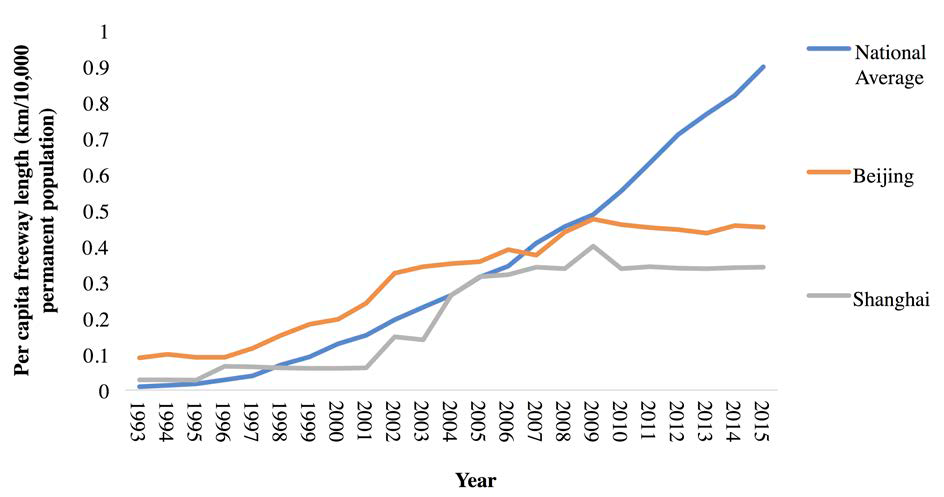
Figure 7: Peak in freeway building in big cities
The big cities have moved away from it and it hasn't
hurt the economy. That's the key thing. The GDP per capita in Beijing has
continued to rise as the per capita VKT (car use) is going down (Figure 8).
This is called decoupling, and it's a very important part of the story as what
we're talking about is not harming the economy, but it's making it better.
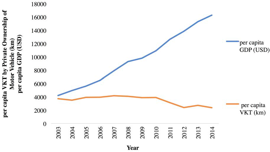
Figure
8: Beijing decouples economic growth from car use
Good Urbanism
A lot of this has been driven by the need for good urbanism.
There are lots of books about the attractions of good density in walkable TODs.
The reality is there are economic and social attractions of walkable urban
design. This is the way most cities want to be now, and driving it is
‘pedestrian density rather than car traffic’.
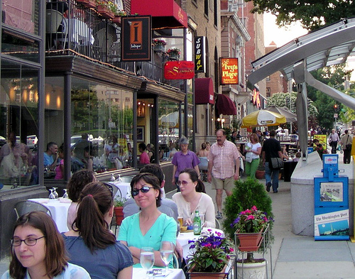
Low urban density drives car use, and higher density gets people out of cars. We therefore should welcome density - it is the solution not the problem to most sustainability issues. Density is essential for jobs. Centers without density don't attract walking and knowledge economy jobs, so transit density and design create walkability. And the data on that is very clear, for example, the top six most walkable cities in the US have thirty eight percent higher GDP. It is not going to harm your economy.
So where is the global transport financing going to help with this good urbanism based on rail not cat dependent roads? According to the Asian Development Bank, they spent 91% in 2010 on roads, and 45% in 2018, and the rest is mostly on urban rail. This is driven by demand. Cities are changing and the transition is underway. But it needs to be facilitated.
The Personal Journey in Perth
Electric trains have been a personal and an academic journey for me for forty years. That's a picture of me forty years ago as I ran the campaign to save our railway in Perth.
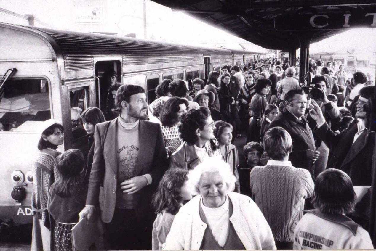
Since then we have built railways right across our city as a bit of a global model for what you can do in regenerating a car-based city. The new Southern Suburbs rail line carries the equivalent of 8lanes of traffic. We now have had an $8 billion dollar project to build railways into all the corridors in the city of Perth. The corridors project is called Metronet and each of the seven now lines have a project to build centres around stations. These Metro Hubs or TOD’s around each station are helping reduce automobile dependence. These TODs are usually well designed and will be important for the future but they are only a small fraction of the city. So what I'm saying is that era is reaching a conclusion and we now need to see what's next that can further reduce automobile dependence.
Is TAC next?
Despite rail and TOD growth, most people are not easily accessing rail lines, even inside the cities with good rail, and where Main Roads remain stuck in traffic, the options are not always favouring alternatives. Can we therefore create a new model that uses Main Roads to bring train-like accessibility and create new urban regeneration nodes around this?
The key is a new type of transit called mid-tier
transit which performs better than a bus and is like a train but doesn’t cost
as much a new train line as it runs in the road. We have called these Trackless
Trams and they are electric (batteries on the roof) with high tech sensors
guiding its run to make it very smooth. They are so attractive for people to
use that developers find the value of land around stations goes up by between
20-50%. This means they are able to facilitate urban regeneration along the
Main Roads where they are placed.
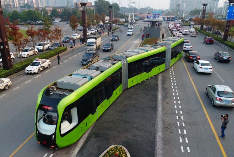
So, can we turn Main Roads into TAC’s: transit activated development? It’s possible that this is the solution we have been looking for that will enable large scale urban regeneration in the ‘missing middle’ of cities around the world. This is the agenda that's now happening in the EU. They have Sustainable Urban Mobility Plans which are emphasizing place and movement along Main Roads, not just increasing capacity for cars.
We have a new map of our city in Perth which shows
Green Routes (Figure 9).These are Main Roads where there's now going to be high
quality transit and density, together, as the priority. That's a change. It is
not increasing road capacity, but it is increasing transit and density. And the
idea is that the urban development would help pay for the high quality transit
system.

Figure
9: Perth City Map
The new Main Road, after becoming a TAC, would have
various nodes along it where there would be local shared mobility and lots of
walkability in station precincts.

Figure
10: Transit Activated Corridor
These precincts built around stations would be 20-30kph areas, and between them where the trackless trams would be free to run quickly would be50-70kph zones. Such a principle of variable speed areas along a Main Road, is what the EU are calling Place and Movement Strategies.
This is what is being created in Australia in a number of cities – Townsville, Sydney, Melbourne and Perth as part of a national research project. The city of Liverpool in Sydney is taking the lead in next generation smart transit in time for the new western Sydney International Airport. The Fifteenth Avenue will be a fast, green transport spine linking jobs to the airport and connecting Liverpool with the world. Next generation smart transit combines the comfort and speed of rail with the convenience and adaptability of a bus. They’re working on new technologies with leaders in Australia and around the world. The smart transit corridor will connect Sydney International with Liverpool city center in style and comfort. It will also connect the existing neighborhood through linked bus and shuttle services, walkways and cycleways. (See https://vimeo.com/414663342)
Next generation smart transit will help connect people and nature with the airport. Closer to Liverpool, fast smart transit will encourage a new style of living, connecting the community and the environment. This will bring people close to jobs, education and recreation options. The stations along the route will be key growth areas for jobs and housing.
So then how do we fund this?
We have what's called the Entrepreneur Rail Model, which is how you get
developers into the system from the start of planning, so that they can help
decide not just what happens but where, in terms of urban development. You
first create “Transit Activated Corridors” to attract the private finance, and
design the transit last.

Figure 11: Conventional Planning VS Entrepreneurial Planning
The entrepreneurial approach is not to start with the engineering, but to start with a land value uplift that is possible. Get the funding from this and then see how the transit fits in. That reverses the normal approach. It uses value capture and we need to have land value capture. This can be done in some of the big cities in Asia.
The first privately funded rail for 100 years, called
BrightLine, has been built in Miami in Florida. The project used land
development opportunities around the stations to pay for the train and line
upgrades. The BrightLine has been very successful. Things are changing. The Pearl
Street District LRT in Portland Oregon has also shown they can get a privately
funded transit activated corridor.

Figure 12: MIAMICENTRAL& BrightLine
So we've put together A Guide and Manual with Application to Trackless Trams (https://sbenrc.com.au/app/uploads/2018/10/TRACKLESS-TRAMS-MANUAL-GUIDE_email.pdf). It’s about how you can integrate transit, land development and finance.
Finally, it is worth saying
that land value is critical in driving our cities.

Figure 13: Financing Model
If you have a fully public approach, you need to put on land-based levies and you lose a lot of value in that process. If you have a fully private approach, with the entrepreneur approach, you can create a lot of value. Governments still play a role, so they need to do land development targets, and ensure integration with the rest of the transit system, public transport prioritization, land assembly, and shared risk - all of these things are a government role. But that doesn't mean they need to fund it all. That's the change that we're moving into because there's a lot more you can do if you can involve private sector from the start.
These are the key recommendations for this process:
- Engage the private sector and land developers as early as possible in partnerships.
- Create a plan for the corridors and transit-oriented centers with new technology transit.
- Engage community through this process so that the technology is shaped around their needs.
- Allow flexibility in plans so the private sector can bring ideas that make cities more livable, safe, resilient and sustainable. That's our job to create the SDGs outcome, but it has to be done in partnership.
- Create beautiful density that drives the best urbanism result.
(The article and photos were provided by Prof. Peter Newman) (2019)
Peter Newman AO is the Lead Author for the UN’s IPCC on Transport, winner of an Order of Australia for sustainable transport and urban design, environmental scientist, author and educator, Professor of Sustainability at Curtin University, Australia.
Peter is an academic who has written 20 books and over 340 papers on sustainable cities with a global reputation and has worked to deliver his ideas in all levels of government. Peter has worked in local government as an elected councilor in Fremantle, in WA state government as an advisor to three Premiers and in the Australian Government on the Board of Infrastructure Australia and the Prime Minister’s Cities Reference Group. In 2014 he was awarded an Order of Australia for his contributions to urban design and sustainable transport particularly for his work in saving and rebuilding Perth’s rail system. In 2018/19 he was the WA Scientist of the Year.
Copyright © Global Forum on Human Settlements (GFHS)
